Milan / Rome, Italy
Terms of Sale
View Demo
The auction has ended
|
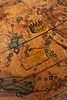
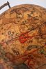
LOT 221:
Celestial and terrestrial globes on turned wood base. 19th century.
more...
|
|


|
Sold for: €5,500
Price including buyer’s premium:
€
7,095
Start price:
€
3,000
Estimate :
€4,000 - €6,000
Buyer's Premium: 29%
More details
|
Celestial and terrestrial globes on turned wood base. 19th century.
h tot. cm 60
Wood, plaster, and papier-mâché spheres covered with twelve engraved and color spindles. Brass sundials. Celestial globe. Near Boote and the constellation of Virgo is the inscribed cartouche "Globo celeste calcolato per il corrente anno sulle osservazioni de' Sigg. Hamsteed e de La Caille. Roma presso la Calc. a Cam. le 1792, Inciso dal P. Gio. M.a Cassini C.R.S." Next to the constellation of Aquila is the table “Magnitude of Stars” with its symbols used for magnitudes and nebulae. Terrestrial globe. In the Atlantic Ocean is the inscribed cartouche “GLOBO TERRESTRE nuovamente delineato rettificato ed accresciuto giusta le più recenti scoperte ROMA presso la calcografia camerale 1843.” Also shown in one of the legends, in the South Sea, is a table presenting the length of the degree of the maximum circle of the terrestrial sphere in 14 different units of measurement. Defects. In the collection of the Specola Museum, Bologna, are a Celestial Globe and an Earth Globe by G.M. Cassini, Rome, 1792. Giovanni Maria Cassini (Venice 1745-Rome 1824), a regular Somasque cleric and disciple of Giovanni Battista Piranesi, was a geographer, cartographer and engraver working in Rome in the decades between the 18th and 19th centuries. He is credited with the invention of a new method of projection, known as Cassini's method, which was also used to produce the 'geographical atlas of the kingdom of Naples in 32 sheets signed by Giovanni Antonio Rizzi Zannoni. Among his major works, in addition to a general map of Italy in 15 sheets published in 1793, we find the Nuovo Atlante Geografico Universale in three volumes published in Rome from 1792 to 1801. The work was commissioned by the Calcografia Camerale in Rome in order to replace the outdated Mercurio Geografico in use in previous decades. Cassini signs all the maps as engraver.
