761 Durham Road Pineville, PA 18946, United States
Terms of sale
View demo
June highlights include a work by Pierre Charles Comte, a sterling tea set, by Gorham in the Medallion pattern, a Pennsylvania Chippendale Walnut Tall Chest, two works by Abbey Ryan, a 2.13 Ct Diamond and Platinum Engagement Ring, a 19th century Meissen Porcelain Coffee Set, outsider art by Scottie Wilson and others, a Sino Tibetan Figure of Shakyamuni, a pair of Chinese Rosewood Cabinets on Stands, a rare large plaster panel by Vally Wieselthier, a Pair of Gothic Revival Leaded Glass Bookcases, a good pair of China Trade School paintings, a large collection of gold and silver coins, various fine art, furniture from the 18th through 20th centuries, and Asian art.
|
LOT 211:
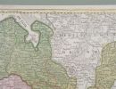
Three Early Maps of Germany
more...
|
|


|
Sold for: $100
Start price:
$
100
Estimated price :
$200 - $300
Buyer's Premium: 21%
More details
sales tax: 6%
On the full lot's price and commission
|
Three Early Maps of Germany
A 1726 map of Kiel by Homann, a circa 1740 Homann map of the Westphalian Circle, Holy Roman Empire (Bonn Cologne), and a 1721 map of Germany and Poland by De Wit.
Dimensions: The frames range from 21 1/2" x 21 1/2" to 27 1/2" x 24 1/2".
Condition: Some stains, losses, and short tears are evident through the glass. Not examined out of the frames.
